 I arrived at Coast Guard
headquarters about 8:30 PM, having passed towns that had come up earlier in
the day — Port
Washington, Belgium, Sheboygan (see regional section of road map). Lt.
Kilroy and Mr. Lewis were waiting for me. When they learned I had not had
dinner, they had a sandwich and potato chips and coffee brought up for
me, and began to brief me immediately.
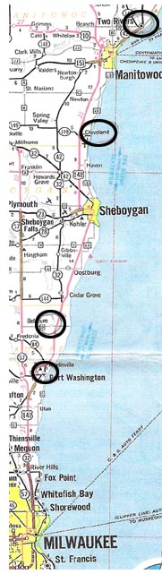
I arrived at Coast Guard
headquarters about 8:30 PM, having passed towns that had come up earlier in
the day — Port
Washington, Belgium, Sheboygan (see regional section of road map). Lt.
Kilroy and Mr. Lewis were waiting for me. When they learned I had not had
dinner, they had a sandwich and potato chips and coffee brought up for
me, and began to brief me immediately.
The surface search on Saturday had covered an area north to south about 35 miles. Although I didn’t note exact shore points, it appeared that this covered an area from Port Washington north to Cleveland. An intensive shore search had been included. The area extended out from shore approximately 10 to 15 miles. This area was blacked out on their map in the communications center. The area was searched in a pattern such that paths of the boats were parallel to each other in 1½ mile intervals. Weather was good and the lake was calm. Under these circumstances they have a high POD (possibility of detection). Although this would be about 525 square miles on a rectangular pattern, they figured some 700 square miles of lake had been searched that day as vessels from stations to the north and south of the area were also included, although not in the in the intensive search area.